Inside 50,000 living rooms: an assessment of global residential ornamentation using transfer learning
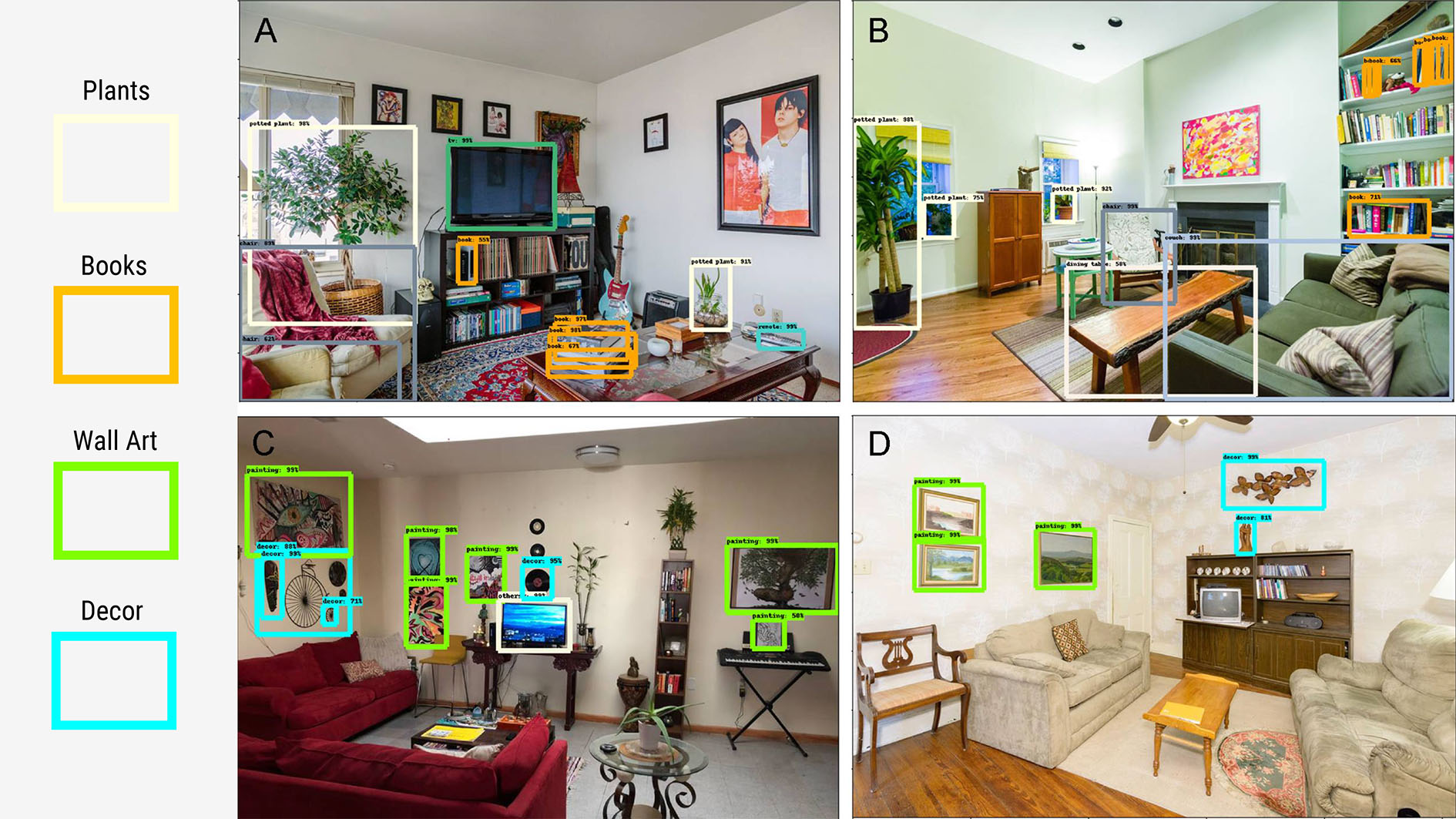
In this work, we collected over one million geolocated images of interior living spaces from a popular home rental website, and used transfer learning techniques to automatically detect the presence of key stylistic objects: plants, books, decor, wall art and predominance of vibrant colors. We investigated patterns of home decor practices for 107 cities on six continents, and performed a deep dive into six major U.S. cities. We found that world regions show statistically significant variation in decorative element prevalence, and American residents in different socio-economic environments put similar effort into personalizing and caring for their homes.
with Clio Andris, Zixuan Huang, and Sohrab Rahimi
Place niche and its regional variability: Measuring spatial context patterns for points of interest with representation learning
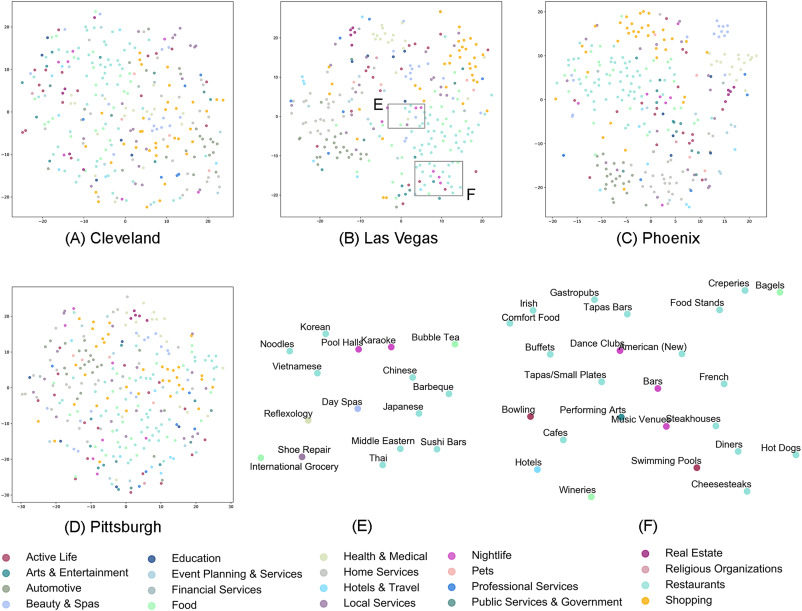
We define the sets of symbiotic places in the proximity of a focal place as the place's “place niche”, which conceptually represents the features of the local environment. We represent the niche as an integrated feature for each type of place, and quantify the niches' variation across cities. Here, with point of interest (POI) data as an approximation of places in cities, we propose representation learning models to explore place niche patterns. With a case study using Yelp data in four U.S. cities, we reveal spatial context patterns and quantified their variations across cities. By exploring patterns for place niche, we not only produce geographical knowledge for business location choice and urban policymaking, but also contribute to the interpretability of machine learning models, and demonstrate the potential and limitations of using spatial context patterns for GIScience tasks such as information retrieval and place recommendation.
with Clio Andris, and Sohrab Rahimi
Revealing travel patterns and city structure with taxi trip data
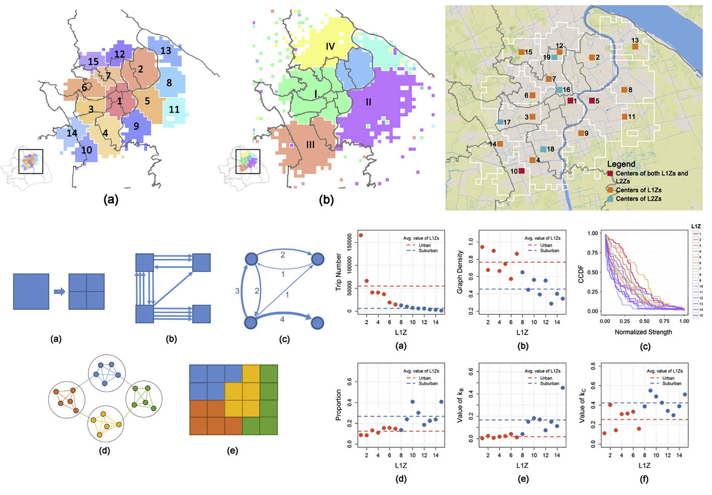
Based on taxi-trip data from Shanghai, we built spatially embedded networks to model intra-city spatial interactions and study urban structure. The community detection method is applied to reveal sub-regional structures, and several network measures are used to examine the properties of sub-regions. Considering the differences between long- and short-distance trips, we reveal a two-level hierarchical polycentric city structure in Shanghai. Land uses of city centers and their influence on travel patterns are also explored.
with Li Gong, Yongxi Gong, and Yu Liu
Incorporating spatial interaction patterns in classifying and understanding urban land use
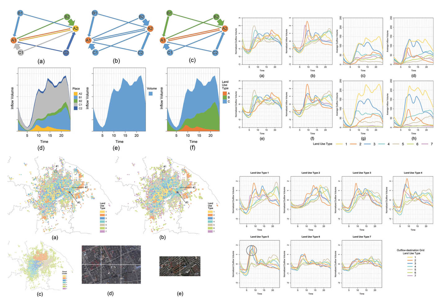
Temporal activity variations derived from ‘big’ geo-data have been used to interpret functions of places. However, the connections/spatial interactions between places has been neglected. In this study, we propose an unsupervised land use classification method using a new type of place signature. The signature, which is a trade-off between aggregated temporal activity variations and detailed spatial interactions among places, represents how a certain place interacts with other type of places. The method is validated with a case study using taxi trip data from Shanghai.
with Chaogui Kang, Li Gong, and Yu Liu
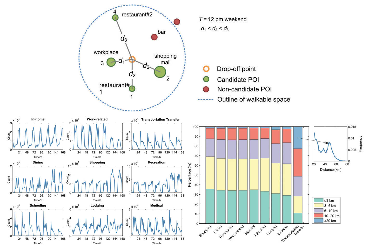
Inferring trip purposes and uncovering travel patterns from taxi trajectory data
This study provides a practical framework for inferring the trip purposes of taxi passengers and enrich taxi trajectory data with semantics. The probability of points of interest to be visited is modeled by Bayes’ rules, which take both spatial and temporal constraints into consideration. Combining this approach with Monte Carlo simulations, we conduct a case study on Shanghai taxi trajectory data. Our results closely approximate the residents’ travel survey data in Shanghai.
with Li Gong, Lun Wu, and Yu Liu
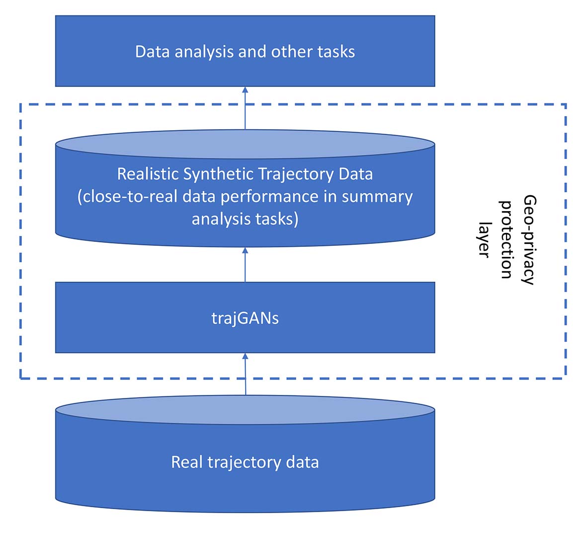
trajGANs: Using generative adversarial networks for geo-privacy protection of trajectory data
We propose the trajGANs framework and address the potential of using generative adversarial networks for geo-privacy protection of trajectory data. Our goal is to provide a geo-privacy protection layer for trajectory data publication and usage by generating synthetic trajectories that can preserve the summary properties of real data and have close-to-real-data performance in analysis tasks. We summarize the trajectory types in geo-privacy protection and the possible data generation scenarios. We also provide validation metrics and address the possible challenges of implementing trajGANs.
with Hanzhou Chen, and Clio Andris
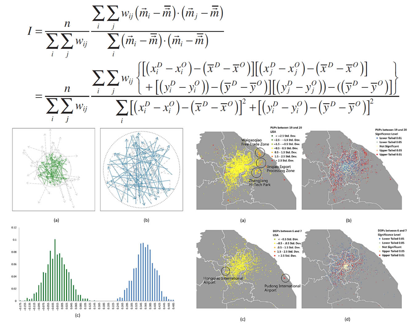
Measuring Spatial Autocorrelation of Vectors
This article introduces measures to quantify spatial autocorrelation for vectors. In contrast to scalar variables, spatial autocorrelation for vectors involves an assessment of both direction and magnitude in space. Extending conventional approaches, measures of global and local spatial associations for vectors are proposed, and the associated statistical properties and significance testing are discussed. The new measures are applied to study the spatial association of taxi movements in the city of Shanghai. Complications due to the edge effect are also examined.
with Yu Liu, Daoqin Tong
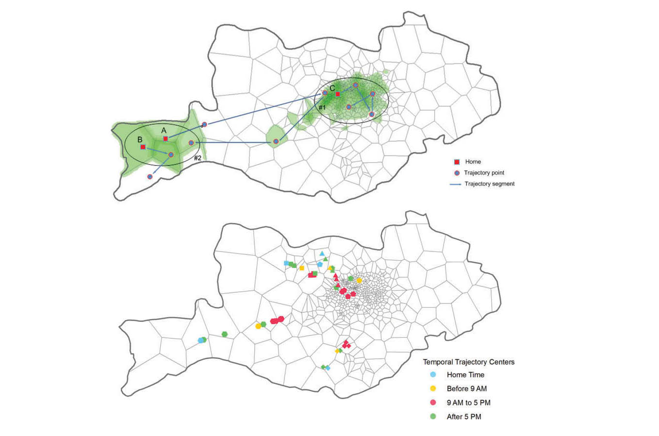
Human mobility patterns in different communities: a mobile phone data-based social network approach
Using an empirical mobile phone dataset, we attempt to explore the spatial distributions of social networks and human mobility patterns, as well as the interrelationship between them, at the community level. Three spatial patterns of communities are identified: single-centered distribution, dual-centered distribution and zonal distribution. We differentiate these communities by analyzing angle distribution of trajectories and radius of gyration of users. Furthermore, we analyze spatial and temporal travel patterns for the users in dual-centered communities. The results indicate that home–work separation and people’s commuting travel brings about spatial interaction between urban district and suburbs.
with Li Shi, Guanghua Chi, and Yu Liu
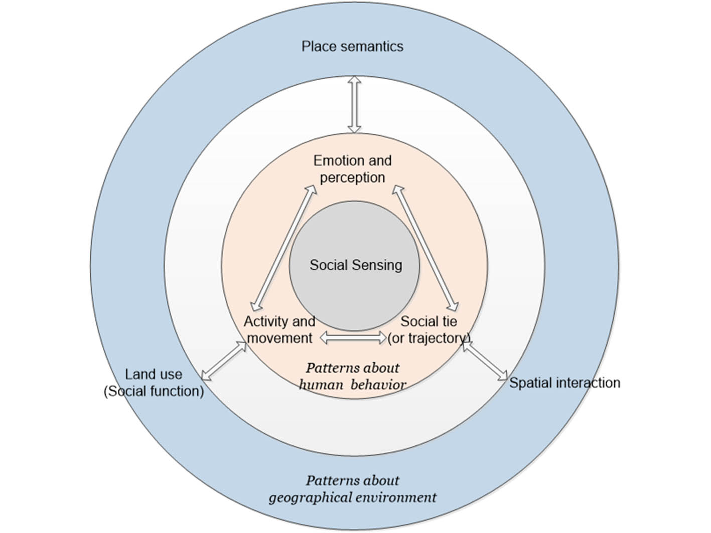
Social sensing: a new approach to understanding our socioeconomic environments
The emergence of big data brings new opportunities for us to understand our socioeconomic environments. We use the term social sensing for such individual-level big geospatial data and the associated analysis methods. The word sensing suggests two natures of the data. First, they can be viewed as the analogue and complement of remote sensing, as big data can capture well socioeconomic features while conventional remote sensing data do not have such privilege. Second, in social sensing data, each individual plays the role of a sensor. This article conceptually bridges social sensing with remote sensing and points out the major issues when applying social sensing data and associated analytics. We also suggest that social sensing data contain rich information about spatial interactions and place semantics, which go beyond the scope of traditional remote sensing data.
with Yu Liu, Song Gao, Li Gong, Chaogui Kang, Ye Zhi, Guanghua Chi, and Li Shi
Hidden Style in the City: An Analysis of Geolocated Airbnb Rental Images in Ten Major Cities
In this study, we analyze geo-located Airbnb rental images in ten major cities. Since hosts advertise their rentals on Airbnb, the site has a wealth of residential interior images from all over the world: from rural Africa to downtown Manhattan. As part of an ongoing project, we have downloaded over 200,000 images posted on Airbnb to ask: how do people decorate their homes in different locales? Do they use certain colors, or have a certain ornate or simple style? Here, we test ten major metropolitan areas using image rating responses from Mechanical Turk as well as automated image color predominance routines to investigate geographical differences in interior styles.
with Sohrab Rahimi, and Clio Andris
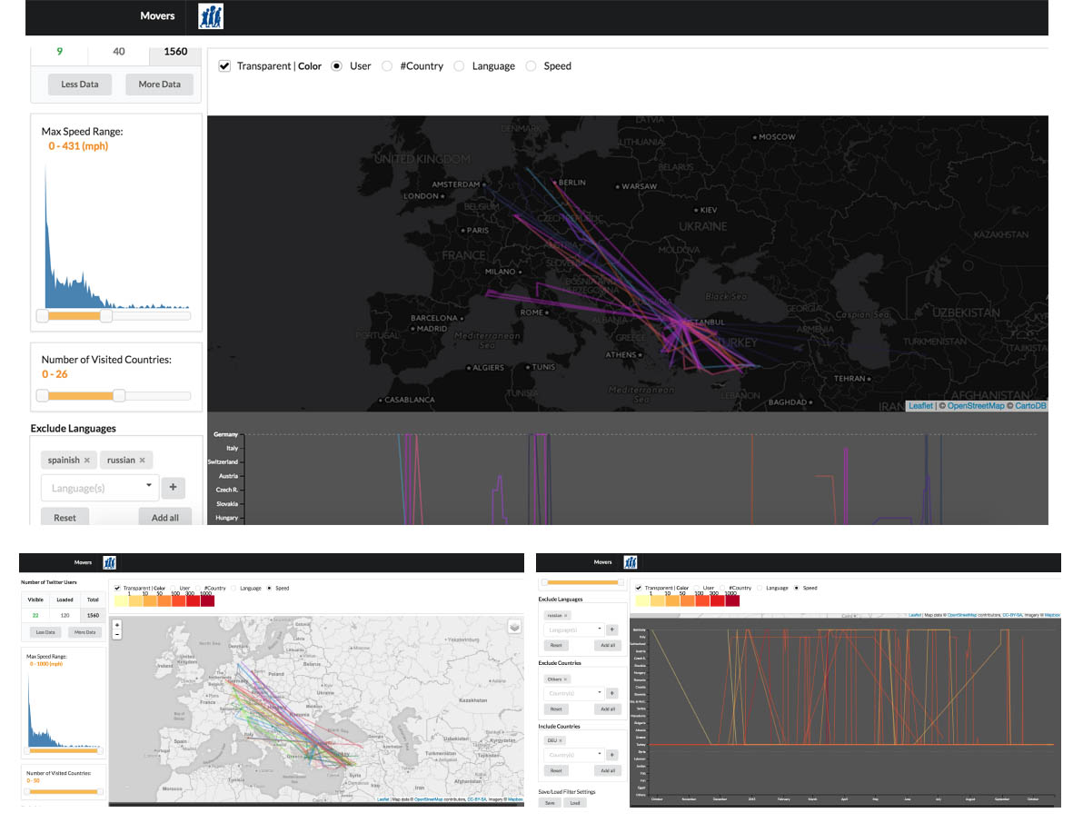
Movers: A Visual Analytics System for Exploring Refugee Movement with Social Media Data
Knowledge of refugee movements can help NGOs and governments better target and provide services to refugees. However, currently available data about refugee movements are sparse and coarse from both spatial and temporal perspectives. We consider social media data such as Twitter, though very “noisy”, having potential to provide useful information about refugee movements. We thus design and build a web-based visual analytics system, Movers, to support analysts to systematically explore geo-referenced Twitter data and identify refugees. The identification of individual Syrian refugees who fled to Germany is used as a case study. The system can also be extended to filter other movement related data for identifying specific type of users.
with Feng Sun, Fridolin Linder, Mark Simpson, Yanan Xin, Ying Xu, Alexander Savelyev, and Alan MacEachren
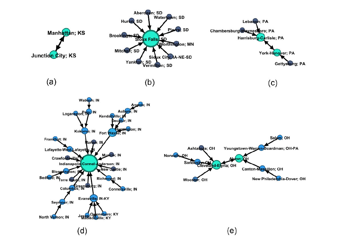
Migrant Routing in the U.S. Urban System
In this article, we create directional networks of U.S. core-based statistical areas where cities link to the most popular destination city of its out-migrants for a given year. Data is sourced from the U.S. Internal Revenue Service. The networks join cities into graph motifs and form “constellations” within the galaxy of cities. Different constellation types correspond to different regional structures of cities. We also create subnetworks based on wealth discrepancies. We find that the network of migrants that has low income reveals a chain of local movements, which is substantially different than that of wealthy migrants, who flock to hub cities. This may result from the better mobility of wealthy migrants.
with Clio Andris